
Sunday, April 25, 2010
Sunset Lake - Vicksburg, MI - Sunken Boat
On only the fourth outing with my underwater camera I was completely surprised to find a sunken boat! Unfortunately, I was drifting pretty quickly so it was really difficult to get a steady shot. I'm hoping to try and get some better footage soon.
Video shot using the Marcum VS825 underwater viewing system.
Location: Sunset Lake, Vicksburg, MI (Kalamazoo County)
Sunday, April 18, 2010
Sunset Lake - Largemouth Bass and Bluegill Video
Some of my recent video footage of largemouth bass and bluegill at Sunset Lake in Vicksburg, MI using the Marcum Underwater Camera System.
Sunday, April 4, 2010
Video Fishing - Using the Marcum VS825c Underwater Camera
This is a murky underwater video clip of Sunset Lake (vicksburg, MI). Although there aren't any fish shown I'm really happy with how this test video turned out. Hopefully, in the future I'll have clips of fish swimming around.
Underwater Camera: Marcum VS825c Color Underwater View System
Sunday, September 13, 2009
Sunday, May 3, 2009
About Kalamazoo Lakes!
KZooLakes.com is a unique source of information for many publicly accessible Kalamazoo County Lakes (Michigan). Within this website you'll find maps and video clips depicting many of your favorite lakes. In addition, this website encourages active participation by YOU! So if you're a local fisherman, boater, waterskier, kayaker etc. this is an excellent place to share your local lake knowledge with others. Lake knowledge such as best times to fish, best lake to waterski, most picturesque lake to kayak etc. etc. To contribute your knowledge just click on the "comment" link at the bottom of each specific lake web page. It's that easy!
Saturday, May 2, 2009
Austin Lake
]
The video clip is better resolution than what the "screenshot" depicts.
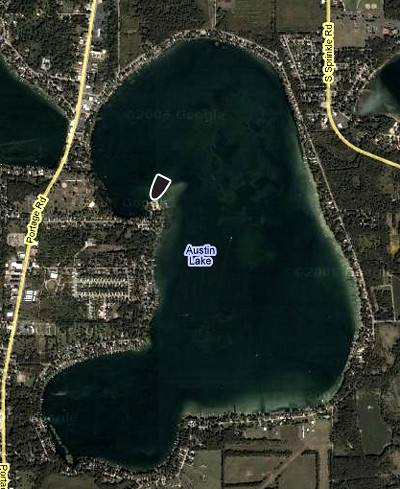
Click Here to Go Directly to Austin Lake on Google Maps
Coordinates: Lat:42.180091, Lon:-85.556235
Surface Area: 1100 Acres
Depths: up to 11 feet
Site Rules:
(1) Site Closed between 11:00 p.m. to 4:00 a.m.
(2) Parks and Recreation Bureau charge a fee for use of the boating access site.
(3) Special rules apply, regarding special closing hours, rules against consumption of alcoholic beverages, and others.
Ramp Description:
A hard-surfaced ramp, launching and retrieving of large boats may be difficult and not recommended. The site is signed.
Total Parking Spaces: 43
FISH SPECIES
• Black Crappie
• Bluegill
• Largemouth Bass
• Muskie
• Northern Pike
• Yellow Perch
src="http://pagead2.googlesyndication.com/pagead/show_ads.js">
The video clip is better resolution than what the "screenshot" depicts.
Click Here to Go Directly to Austin Lake on Google Maps
Coordinates: Lat:42.180091, Lon:-85.556235
Surface Area: 1100 Acres
Depths: up to 11 feet
Site Rules:
(1) Site Closed between 11:00 p.m. to 4:00 a.m.
(2) Parks and Recreation Bureau charge a fee for use of the boating access site.
(3) Special rules apply, regarding special closing hours, rules against consumption of alcoholic beverages, and others.
Ramp Description:
A hard-surfaced ramp, launching and retrieving of large boats may be difficult and not recommended. The site is signed.
Total Parking Spaces: 43
FISH SPECIES
• Black Crappie
• Bluegill
• Largemouth Bass
• Muskie
• Northern Pike
• Yellow Perch
src="http://pagead2.googlesyndication.com/pagead/show_ads.js">
Friday, May 1, 2009
Barton Lake
The video clip is better resolution than what the "screenshot" depicts.
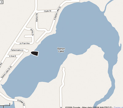
Click Here to Go Directly to Barton Lake on Google Maps
Coordinates: Lat:42.097189, Lon:-85.569381
Surface Area: 329 Acres
Ramp Description:
A hard-surfaced ramp, launching and retrieving of large boats may be difficult and not recommended. The site is signed.
Total Parking Spaces: 26
FISH SPECIES
• Black Crappie
• Bluegill
• Largemouth Bass
• Northern Pike
• Rock Bass
• Smallmouth Bass
• Sunfish
• Yellow Perch
src="http://pagead2.googlesyndication.com/pagead/show_ads.js">
Thursday, April 30, 2009
Eagle Lake (Charleston Twp.)
The video clip is better resolution than what the "screenshot" depicts.
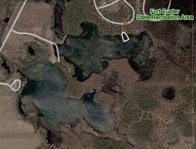
Click Here to Go Directly to Eagle Lake on Google Maps
Located in the Fort Custer Recreation Area where a State Park entrance permit is required and State park rules apply.
Coordinates: Lat:42.329569, Lon:-85.319477
Surface Area: 194 Acres
Depths: Up to 10 feet
Ramp Description:
A hard-surfaced ramp, launching and retrieving of large boats may be difficult and not recommended. The site is signed.
Total Parking Spaces: 14
FISH SPECIES
• Black Crappie
• Bluegill
• Largemouth Bass
• Northern Pike
• Sunfish
• Yellow Perch
Wednesday, April 29, 2009
Eagle Lake
The video clip is better resolution than what the "screenshot" depicts.
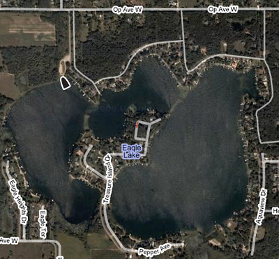
Click Here to Go Directly to Eagle Lake on Google Maps
Coordinates: Lat:42.219377, Lon:-85.725321
Surface Area: 265 Acres
Depths: up to 12 feet
Total Parking Spaces: 14
Site Rules:
(1) Site Closed between 11:00 p.m. to 4:00 a.m.
(2) Special rules apply, regarding special closing hours, rules against consumption of alcoholic beverages, and others.
Ramp Description:
A gravel-surfaced ramp, suitable for medium sized and smaller boats. The site is signed.
Total Parking Spaces: 30
FISH SPECIES
• Black Crappie
• Bluegill
• Largemouth Bass
• Northern Pike
• Yellow Perch
Tuesday, April 28, 2009
Gull Lake
The video clip is better resolution than what the "screenshot" depicts.
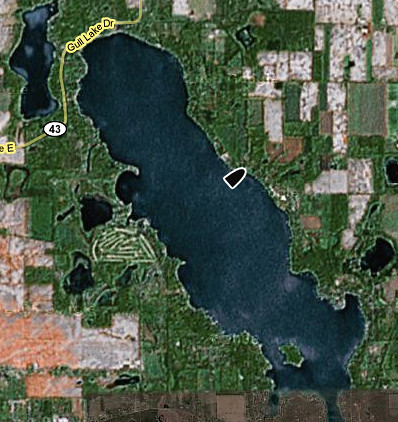
Click Here to Go Directly to Gull Lake on Google Maps
Coordinates: Lat:42.426317, Lon:-85.428871
Surface Area: 2,050 Acres
Depths: Up to 110 feet
Ramp Description:
A gravel-surfaced ramp, launching and retrieving of large boats may be difficult and not recommended.
*** A larger access site is located on Baseline Rd off of E. Gull Lake Dr. (in Barry County), with parking (92 spaces) and restrooms. A Fee is required. Ramp is hard-surfaced. Launching big boats may be difficult.****
FISH SPECIES
• Black Crappie
• Bluegill
• Largemouth Bass
• Northern Pike
• Rainbow Trout
• Rock Bass
• Smallmouth Bass
• Sunfish
• Yellow Perch
Monday, April 27, 2009
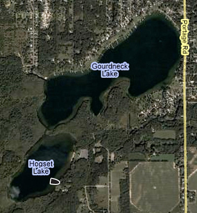
Hogset & Gourdneck Lakes
The video clip is better resolution than what the "screenshot" depicts.
Click Here to Go Directly to Austin Lake on Google Maps
Hogset Lake’s boat access is located in Prairie View Park. A paid park permit is required.
Hogset and Gourdneck Lakes are connected by a clearly marked channel buoys.
Hogset Lake Coordinates: Lat:42.149118, Lon:-85.590275
Surface Area: Hogset Lake - 81 acres. Gourdneck Lake - 222 acres.
Depths: Hogset Lake - Up to 32 feet. Gourdneck Lake - Up to 52 feet.
Ramp Description: A gravel-surfaced ramp, suitable for medium-sized and smaller boats. The site is signed.
Total Parking Spaces: 4
FISH SPECIES
• Black Crappie
• Bluegill
• Largemouth Bass
Sunday, April 26, 2009
LeFevre Lake
The video clip is better resolution than what the "screenshot" depicts.
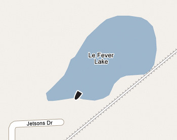
Click Here to Go Directly to LeFevre Lake on Google Maps
Coordinates: Lat:42.218495, Lon:-85.374583
Surface Area:18 acres
Depths: up to 24 feet
Ramp Description:
A gravel-surfaced ramp is suitable for medium and small sized boats.
Total Parking Spaces:10
FISH SPECIES
• Largemouth Bass
• Panfish
Saturday, April 25, 2009
Long Lake
The video clip is better resolution than what the "screenshot" depicts.
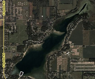
Click Here to Go Directly to Long Lake on Google Maps
Coordinates: Lat:42.185396, Lon:-85.537861
Surface Area: 575 AcresDepth: Up to 57 feet
Ramp Description:
A hard-surfaced ramp, launching and retrieving of large boats may be difficult and not recommended. The site is signed.
Total Parking Spaces: 24
FISH SPECIES
• Black Crappie
• Bluegill
• Largemouth Bass
• Northern Pike
• Rock Bass
• Sunfish
• Yellow Perch
Friday, April 24, 2009
Morrow Lake
The video clip is better resolution than what the "screenshot" depicts.
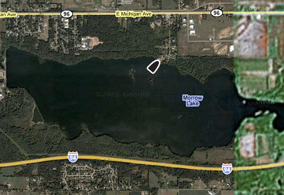
Click Here to Go Directly to Morrow Lake on Google Maps
Morrow Lake is also known as Morrow Pond.
Coordinates: Lat:42.282685, Lon:-85.466521
Surface Area: 1000 Acres
Ramp Description:
A hard-surfaced ramp, launching and retrieving of large boats may be difficult and not recommended. The site is signed.
Total Parking Spaces: 24
FISH SPECIES
• Black Crappie
• Bluegill
• Catfish
• Largemouth Bass
• Northern Pike
• Rock Bass
• Smallmouth Bass
• Sunfish
• Walleye
Thursday, April 23, 2009
Paw Paw Lake
The video clip is better resolution than what the "screenshot" depicts.
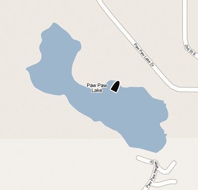
Click Here to Go Directly to Paw Paw Lake on Google Maps
Paw Paw Lake is also known as Little Paw Paw Lake.
Coordinates: Lat:42.160425, Lon:-85.743242
Surface Area: 126 Acres
Depth: Up to 56 feet
Ramp Description:
A hard-surfaced ramp, launching and retrieving of large boats may be difficult and not recommended. The site is signed.
Total Parking Spaces: 9
FISH SPECIES
• Black Crappie
• Bluegill
• Largemouth Bass
• Rainbow Trout
• Rock Bass
• Sunfish
Wednesday, April 22, 2009
Pickerel Lake
The video clip is better resolution than what the "screenshot" depicts.
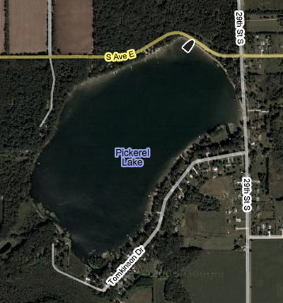
Click Here to Go Directly to Austin Lake on Google Maps
Surface Area: 135 AcresDepth: Up to 10 feet
Ramp Description:
Two gravel-surfaced inclines located on S Avenue.
FISH SPECIES
• Black Crappie
• Bluegill
• Largemouth Bass
• Northern Pike
Subscribe to:
Posts (Atom)